Descriptions
Located in Uttarakhand, Kalindi Khal Trek is the most famous trekking pass of the Garhwal Himalayas. Kalindi Pass or Kalindi Khal is a high-altitude mountain pass that connects Gangotri and Ghastoli. The expedition is filled with thrilling adventures and passes through several historic spots and peaks from Indian mythology, including Gaumukh (origin point of Ganga), Vasuki Parvat, and many more.
The expedition starts from Delhi and reaches the Kalindi Pass height of 19,521 ft. The Kalindi Khal itinerary crosses some of the scenic destinations of Uttarakhand, including Dehradun, Mussoorie, Harsil, Gangotri, and plenty more. It is one of the most scenic road trips accompanied by the great Himalayan views alongside lush natural settings.
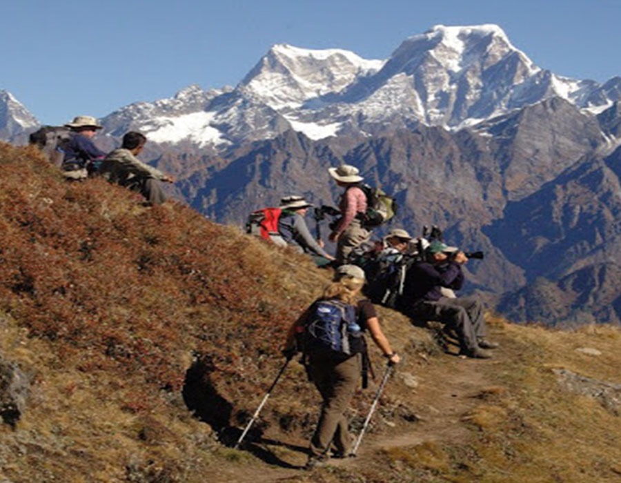
Notice how the terrain changes since the starting of the trek. As the nature of the road changes from plains to a little curvy mountain view roads. Cross through Harsil, the hidden gem of Uttarakhand. The village name, Harsil has a beautiful mythological tale. According to the local legend, once the river Bhagirathi and the Jalandhari argued over their significance. Vishnu, also known as Hari, was summoned and transformed into a massive stone (shila), absorbing their rage. Even now, the waters of the two rivers have become less tumultuous since Hari-Shila (or Harsil).
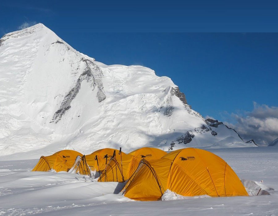
Throughout the trek, you will hike through glaciers, mountains, and moraines. Hence, adventure is guaranteed. And don't worry about your safety. You will be roped, carefully while you cross the crevasses and tricky patches. Not to mention, guided under the supervision of highly trained professionals. Besides, you will be journeying alongside a spellbinding network of mountains, circled by moraine and setting camps at some of the most serene & stunning mountain backdrops.
Another mythological spot in the trek is Gangotri. It is one of the most popular Hindu pilgrim sites, which is also one of the four sites in the Chota Char Dham pilgrimage circuit. According to Hindu folklore, it is at this spot where Goddess Ganga descended on the earthly plain when the almighty Shiva released the mighty river from his dreadlocks. Take a small tour of beautiful temples around the town, inhabited by sadhus and pilgrims. Later, start your trek to Chirbasa.
Hike through various river streams, gradually ascending on the way forward. En route, you will also make a short trek to Gaumukh, the holiest place of Hindus worldwide. In 1972, Mauritius' then-Prime Minister, Sir Seewoosagur Ramgoolam, transported holy Ganga water from Gaumukh and combined it with water from Grand Bassin in Mauritius, renaming it Ganga Talao for Mauritian Hindus. You can now appreciate the significance and effect of this location.
The Kalindi Pass is located at an astonishing height and is majorly covered in snow. This is why you will be hiking with proper acclimatization breaks throughout the route. Apart from this, capture the glimpse of Bhagirathi, Bhrigu Parbat, Kedar Dome peak, and other magnificent peaks. In addition to that, you will spend a day camping and acclimatizing beside the charming Vasuki Tal.
Lastly, enjoy the jaw-dropping views from the Kalindi Khal peak and head back to Mana Village via Arwatal and Ghastoli. Mana is the last settlement before the Mana Pass and is situated just 26 kilometers from India and Tibet border. Later take a driveway to the Hindu Pilgrimage Badrinath, followed by visiting a popular skiing point- Auli. Retire in a comfortable lodge, since the next day marks the end of the Kalindi Khal expedition.
Wake up on the last day of the trek, have your breakfast and start your forward journey to Delhi. The Kalindi Khal trek ends at reaching Delhi.
Difficulty Level
Grade: Very Difficult / Expedition Level
The Kalindi Khal Trek is one of the most challenging high-altitude treks in India. The route involves extended glacier travel, technical snow crossings, and camping at altitudes above 18,000 ft for multiple nights. The summit push on Day 13 begins at 1:00 AM and can take 8–13 hours depending on snow and weather conditions.
This expedition is strictly for experienced trekkers who have previously completed treks above 14,000–15,000 ft such as Roopkund, Stok Kangri, or Satopanth Lake Trek. Good cardiovascular fitness and prior exposure to glacier terrain are essential.
Kalindi Khal Trek Altitude Profile
| Campsite | Altitude (ft) |
|---|---|
| Chirbasa | 11,646 |
| Bhojwasa | 12,400 |
| Tapovan | 14,202 |
| Nandanvan | 14,229 |
| Vasuki Tal | 16,010 |
| Khara Pathar | 17,979 |
| Shweta Glacier | 18,044 |
| Kalindi Base Camp | 18,372 |
| Kalindi Khal Summit | 19,521 |
| Arwatal | 13,057 |
| Ghastoli | 12,454 |
Key Takeaways
- Duration: 16 Days / 15 Nights from Delhi
- Maximum Altitude: 19,521 ft (5,947 m) at Kalindi Khal Pass
- Difficulty: Very Difficult — experienced trekkers only
- Best Time: June to September
- Route: Delhi → Dehradun → Harsil → Gangotri → Tapovan → Vasuki Tal → Kalindi Khal Pass → Mana Village → Badrinath → Auli → Delhi
- Highlights: Gaumukh, Tapovan, Shivling views, Vasuki Tal, Kalindi Khal summit, Badrinath darshan, Auli
- Includes: All stays, meals, transport, trek leader, permits, first aid, porter/mules
Program
Day 1: Delhi to Dehradun
Drive: 280 km (6 Hours) Meal: Light snacks + Dinner Stay: Hotel on sharing basis
- Reach Delhi, meet our team and enjoy some snacks and tea/coffee during the meet and greet.
- Post the snacks on board your cab and get transferred to Dehradun.
- During the journey you will gain some of the elevation, the nature of the road changes from plains to a little curvy Mountain View roads.
- Reach Dehradun, check in to your hotel, have your hot dinner and retire for the day.
Day 2: Dehradun to Harsil
Drive: 220 km (8 Hours) Altitude: 8,530 ft Meal: Breakfast + Lunch + Evening snacks + Dinner Stay: Lodge on a sharing basis
- Wake up to a fresh morning, enjoy your morning tea with early mountain views from the property.
- Have your breakfast and get ready for a journey to Harsil.
- During the drive you will pass through Mussoorie (known as Queen of Hills) and Uttarkashi.
- Being a charming small village, Harsil is the hidden gem of Uttarakhand with striking views of the Himalayas.
- Reach Harsil, check into your Lodge and with a hot meal retire for the day.
Day 3: Harsil to Gangotri, Trek to Chirbasa
Drive: 26 km (45 min) Trek: 9 km (6 hours) Altitude: 10,006 ft, 11,646 ft Meal: Breakfast + Lunch + Evening snacks + Dinner Stay: Stay in tents on sharing basis
- Wake up to striking Himalayan views, have your breakfast and get ready for a drive to Gangotri (trek start point).
- Reach the holy town of Gangotri, inhabited by many sadhus and pilgrims. Take a small tour of beautiful temples around.
- Start your trek to Chirbasa, enjoy a decent gradual incline with many streams crossing your way.
- Upon reaching Chirbasa, set up your tents and prepare for the acclimatization night.
Day 4: Chirbasa to Bhojwasa
Trek: 5 km (3 hours) Altitude: 12,400 ft Meal: Breakfast + Lunch + Evening snacks + Dinner Stay: Stay in tents on sharing basis
- Wake up to a chilly morning, have your breakfast and get ready for a trek to Bhojwasa.
- During the trek you will pass through Bhagirathi, Shivling, and Bhrigu Parbat peak views.
- Reach Bhojwasa, settle down in your camps and get acclimatized to the place.
- Post lunch, trek to Gaumukh and enjoy the views around. It is the origin of river Ganga.
- Head back to the campsite and post Dinner retire in the cozy tents.
Day 5: Bhojwasa to Tapovan
Trek: 9 km (6 hours) Altitude: 14,202 ft Meal: Breakfast + Lunch + Evening snacks + Dinner Stay: Stay in tents on sharing basis
- Wake up early in the morning, have breakfast and get ready for a trek to Tapovan.
- During the trek you will pass through various moraine sections with stunning mountains serving as huge backdrops.
- Reach Tapovan, set up your camps with stunning views of Meru and Bhagirathi I, II, and III peaks.
- In the evening, retire in your tents after a healthy meal.
Day 6: Relaxation and Acclimatization Day at Tapovan
Altitude: 14,202 ft Meal: Breakfast + Lunch + Evening snacks + Dinner Stay: Stay in tents on sharing basis
- Wake up to a lazy morning and have your breakfast. This will be your acclimatization day.
- Take a nature walk around the campsite or climb the Shivling base camp.
- You can even ascend right up to the Kirti glacier or just spend the entire day at the base camp.
- Head back to the campsite and with a hot meal retire for the day.
Day 7: Tapovan to Nandanvan
Trek: 5 km (3–4 hours) Altitude: 14,229 ft Meal: Breakfast + Lunch + Evening snacks + Dinner Stay: Stay in tents on sharing basis
- Wake up to a refreshing morning, have your breakfast and prepare for Nandanvan.
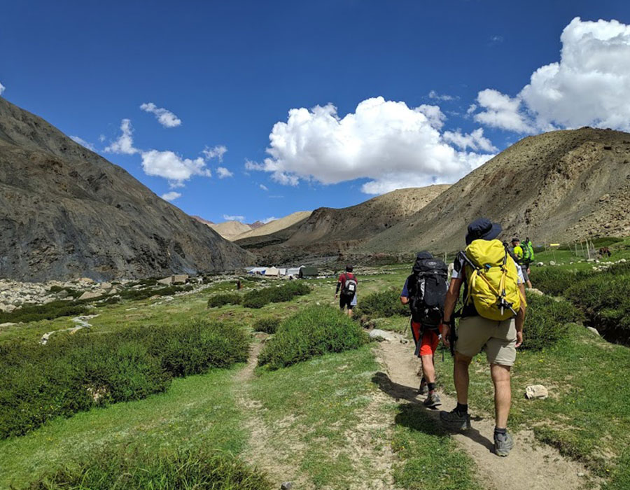
- The trail ascends and descends, and is adorned with glaciers, streams, and moraines.
- Reach Nandanvan and relish the vision that is the peaks of Shivling, Bhagirathi, Sudarshan, Thelu, and Kedar Dome.
- Set up your tents and rest with magical views.
Day 8: Nandanvan to Vasuki Tal
Trek: 5 km (3–4 hours) Altitude: 16,010 ft Meal: Breakfast + Lunch + Evening snacks + Dinner Stay: Stay in tents on sharing basis
- Wake up to a chilly morning, have your breakfast and prepare for Vasuki Tal.
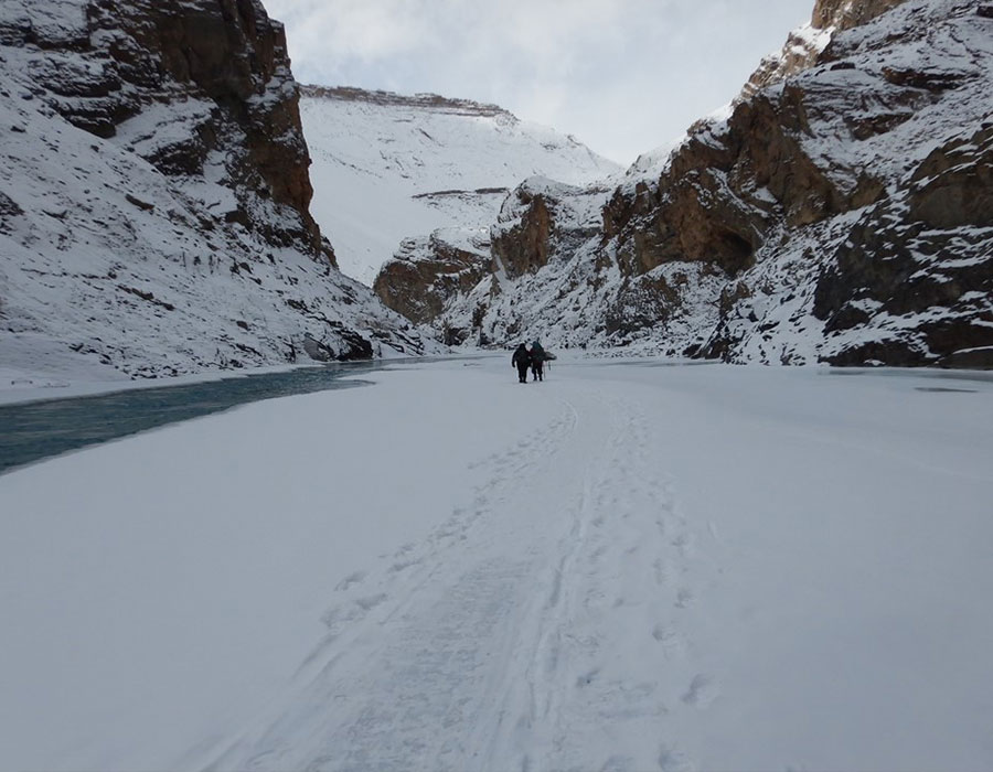
- The trail mostly climbs upon the Chaturangi Glacier. You will cross the lake and the trek team will use ropes for proper safety.
- Upon arriving at the lake, take in the scenic sights of the place and come across other trekking teams scaling the nearby peaks.
- Pitch your tents and have a hot meal for the day.
Day 9: Relaxation and Acclimatization Day at Vasuki Tal
Altitude: 16,010 ft Meal: Breakfast + Lunch + Evening snacks + Dinner Stay: Stay in tents on sharing basis
- Wake up to a lazy morning and have your breakfast. This will be your acclimatization day.
- Today you just have to relax and absorb the nature around you.
- Have your meals and retire for the day in tents.
Day 10: Vasuki Tal to Khara Pathar
Trek: 5 km (3–4 hours) Altitude: 17,979 ft Meal: Breakfast + Lunch + Evening snacks + Dinner Stay: Stay in tents on sharing basis
- Wake up to a healthy breakfast and begin the trek filled with moraine paths.
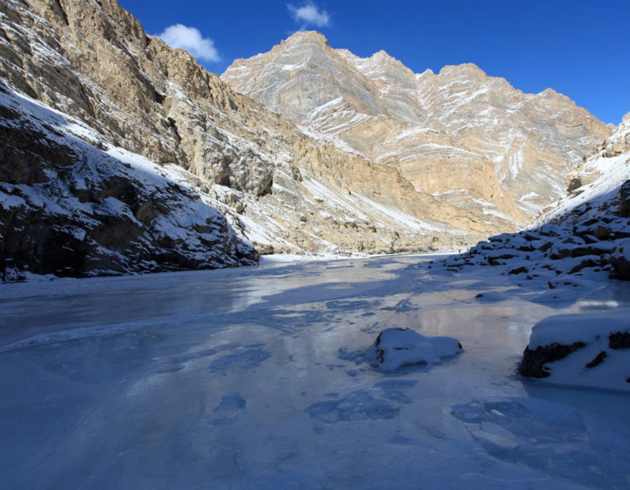
- During the trek you can witness a spellbinding network of mountains as you continue trekking until you arrive at Khara Pathar, which is circled by moraine.
- Set up camp at Khara Pathar, surrounded by the dramatic moraine landscape, and rest after a full day on high-altitude terrain.
Day 11: Khara Pathar to Shweta Glacier
Trek: 6 km (4–5 hours) Altitude: 18,044 ft Meal: Breakfast + Lunch + Evening snacks + Dinner Stay: Stay in tents on sharing basis
- Wake up to a fresh morning, have your breakfast and get ready for Kalindi Pass trekking.
- You will trek through a landscape consisting of glaciers, mountains, and moraine.
- Post the 4–5 hours of trekking, set your camps on the moraine and spend the night in the cozy tents.
Day 12: Shweta Glacier to Kalindi Base Camp
Trek: 5 km (4–5 hours) Altitude: 18,372 ft Meal: Breakfast + Lunch + Evening snacks + Dinner Stay: Stay in tents on sharing basis
- Wake up to an exciting morning, have a quick breakfast, and get ready for breathtaking terrains, a network of mountains and glaciers.
- Reach Kalindi Base Camp, have a sight of the route lying till the peak.
- Pitch your tents. In the evening you'll have a safety briefing about the remaining route.
- Have your sumptuous dinner and retire for the night.
Day 13: Kalindi Base Camp to Kalindi Khal and to Arwatal
Trek: 9 km (8–13 hours) Altitude: 19,521 ft and descent to 13,057 ft Meal: Breakfast + Lunch + Evening snacks + Dinner Stay: Stay in tents on sharing basis
- Wake up as early as 1:00 AM, start your ascending trek through challenging trails depending on snow and weather conditions.
- You will be roped for the entire climb due to crevasses and tricky patches.
- Take in the breathtaking views once you arrive at the Kalindi Khal Summit.
- Post enjoying your time at the top, descend down to Arwatal with a few breaks along the way.
- Reach the campsite, have a hot cup of tea and celebrate the day's thrilling trek.
- Rest in tents with hot meals.
Day 14: Arwatal to Ghastoli
Trek: 7 km (5–6 hours) Altitude: 12,454 ft Meal: Breakfast + Lunch + Evening snacks + Dinner Stay: Stay in tents on sharing basis
- Wake up to a fresh morning, have your breakfast and get ready to trek down to Ghastoli.
- During the trail you will cross 3–4 river crossings and enjoy a fetching walk.
- Reach Ghastoli and encounter army establishment on the Tibet and China border.
- Consume hot tea, interact with soldiers and pitch your tents beside the charming Arwa River.
Day 15: Ghastoli to Mana Village and Drive to Badrinath–Auli
Drive: 50 km (2 hours) Trek: 7 km (5–6 hours) Meal: Breakfast + Lunch + Evening snacks + Dinner Stay: Stay in a lodge on sharing basis
- Have your breakfast and start your adventure from Ghastoli. Continue descending to Mana on well-constructed trails.
- Take in the breathtaking grandeur of Mana, the final town on the Indian side located a few kilometres from the Indo-Tibet border.
- Ride from here to the holy township of Badrinath where you can seek blessings for the journey ahead.
- Take a driveway to Auli, a popular skiing destination where you may relax in a pleasant lodge.
Day 16: Auli to Delhi
Drive: 550 km (10–12 hours) Meal: Breakfast + Lunch + Evening snacks
- Wake up on the last day of the trek, have your breakfast and start your forward journey to Delhi.
- Post reaching Delhi your trek ends.
How to Reach
By Air: Fly into Indira Gandhi International Airport, New Delhi (DEL). Our representative will meet you at the airport and guide you to the group meetup point. From Delhi, all further transport to Dehradun and beyond is arranged by us.
By Train: If arriving from other cities, Hazrat Nizamuddin (NZM) or New Delhi Railway Station (NDLS) are the best entry points. Overnight trains from Delhi to Dehradun (Dehradun Express, Nanda Devi Express) are also available for those joining the group directly at Dehradun on Day 1.
By Road: Delhi to Dehradun is approximately 280 km (5–6 hours via NH 334B through Haridwar or via Meerut–Muzaffarnagar). All road transfers from Delhi onward — through Harsil, Gangotri, and back from Auli — are fully included in the package.
Things to Carry
- Shirts / T-shirts – 5/6, Trekking Pants – 5/6
- Windproof jacket of decent quality preferably with a hood
- Warm and thick Fleece / Full-sleeve Woollen sweater
- Thermal inner wear (upper & lower), Scarf / muffler
- Woollen cap, Woollen gloves, Woollen socks & regular socks (5–6 pairs)
- Comfortable Trekking shoes (Waterproof with a thick sole are recommended)
- Lightweight floaters / sandals / slippers
- Raincoat / Poncho, Small quick dry towel
- Water bottle (sturdy ones)
- Cap / Hat to keep the strong sun away from your face
- Sunglasses (polarized / UV Protected), Walking stick / Trekking pole
- Sunscreen Lotion, Lip Balm, Torch / Flashlight (with extra batteries)
- Medicines, if requiring any specific medication
- Personal toiletries
- Day pack / small bag in case you are planning to offload your regular backpack
- Hand Sanitizer
- Extra face masks
- Valid government ID proof (Passport / Aadhaar)
- Sleeping bag rated to -20°C (confirm with operator if provided)
- Gaiters (for deep snow sections near summit)
- High-altitude snacks: nuts, energy bars, dark chocolate
- Blister prevention tape / moleskin
Best Time for Kalindi Khal Trek
Recommended Window: June to September
June: The pass opens as pre-monsoon snow stabilises. Days are long, glaciers are firm. Best window for the summit push. Some snowfall possible on approach days.
July: Peak season. Clear mornings, manageable glaciers, long daylight hours. Some afternoon cloud near lower camps.
August: Monsoon affects the road approach but the upper glacier is drier. Conditions near the pass remain good.
September: Excellent clarity, cold nights, stable snow. One of the best months for summit views. Days are slightly shorter — keep this in mind for planning.
Before June / After September: Not recommended. Heavy snow on the high glacier sections makes the pass impassable and dangerous.
Most groups with Himalayan Holidays run Kalindi Khal batches in late June and July for optimal conditions.
Weather on Kalindi Khal Trek
Campsite / Zone | Day Temp (June–July) | Night Temp (June–July) Harsil / Gangotri area | 15–22°C | 5–10°C Tapovan / Nandanvan | 8–14°C | -2 to 2°C Vasuki Tal | 4–10°C | -5 to -8°C Khara Pathar and above | 0–6°C | -10 to -14°C Kalindi Khal Pass (summit) | -3 to 2°C | Extreme / wind chill applies
Carry a sleeping bag rated to -20°C for high camps. Wind on the pass can make temperatures feel significantly colder.
Permits Required for Kalindi Khal Trek 2026
The trek passes through Gangotri National Park, which requires:
- Gangotri National Park Entry Fee — Indian nationals: ₹150 per person | Foreign nationals: ₹600 per person (approximate; subject to revision)
- Forest camping permit — Included in the Himalayan Holidays package
- Valid Government Photo ID — Aadhaar card (Indian nationals) or Passport (foreign nationals) is mandatory throughout the trek
All permits and forest fees are managed by our team. Trekkers only need to carry their personal ID proof.
Physical Fitness Requirements
Start preparing at least 6–8 weeks before departure:
- Run or brisk-walk 5–7 km daily
- Include stair climbing or incline treadmill at least 3 times per week
- Practice carrying a loaded daypack of 8–10 kg on walks
- Avoid smoking for at least 4–6 weeks before the trek
Trekkers with a history of cardiac conditions, severe asthma, or prior altitude sickness must consult a physician before booking and inform our team at time of registration.
Safety Guidelines
- Altitude Sickness (AMS): Do not ascend if you experience persistent severe headache, disorientation, vomiting, or difficulty breathing. Inform the trek leader immediately — descent is the only cure.
- Summit Day (Day 13): Stay roped at all times. Do not step off the trail. Weather can change rapidly near the pass.
- No solo movement on glacier sections. Always stay within sight of the group or trek leader.
- Do not skip acclimatisation days (Days 6 and 9). These are non-negotiable safety measures built into the itinerary.
- Emergency evacuation: Portable oxygen cylinders and a first aid kit are carried by the team. Helicopter evacuation can be coordinated in emergency situations.
- Zero-waste camping is practised on this expedition. All waste must be carried back out. Gangotri National Park has strict littering rules.
Price & Inclusions
On Request
Inclusion Details
- All Stays during the trek: (i) Stay in Lodge / Hotel on Day 1, 2 & 15 on a sharing basis (ii) Stay in Tents during the trek from Day 3 to Day 14 on a sharing basis
- Transportation from Delhi to Guest House / Hotel on Day 1 and back to Delhi on Day 16.
- All meals included from Day 1 Light snacks to Day 16 evening snacks. Vegetarian meals will be served throughout the trek.
- Skilled local staff who have ample knowledge of the route.
- Kitchen, dining and toilet tents will be used during the trek.
- Mules / Porter for carrying common equipment like rations / tents / utensils / groceries.
- Experienced trek leader (English speaking) who has ample knowledge of the route.
- Basic First Aid Kit with portable oxygen cylinders.
- Forest entry and permit fee.
Exclusion
- The above trek charges do not include GST charges (5%).
- In case your trek remains incomplete or uninitiated because of "force majeure", medical emergency, or by personal choice after you arrive at the starting point, you will not be able to get a refund, reschedule or replace any services that remain unutilized by you.
- Permit fee for foreign travelers.
- Anything which is not included in Inclusions.
FAQs
Q1. When does Kedarnath Temple open in 2026?
The Kedarnath Temple opening date for 2026 is announced each year by the Badrinath-Kedarnath Temple Committee (BKTC), usually on Mahashivratri. The temple generally opens in late April or early May on Akshaya Tritiya and closes around Bhai Dooj in October–November. For confirmed 2026 dates, contact us directly or check the official BKTC portal before booking.
Q2. What is the distance from Gaurikund to Kedarnath?
The trek from Gaurikund to Kedarnath is 19 km one way. After the 2013 flood, the original 14 km route was modified and the current trail is 19 km. Most trekkers take 6–8 hours for the ascent and 4–5 hours for the descent.
Q3. How difficult is the Kedarnath trek?
The Kedarnath trek is moderately difficult. It involves a continuous uphill climb over 19 km with an altitude gain of approximately 1,700 m from Gaurikund (6,400 ft) to Kedarnath (11,657 ft). It is manageable for reasonably fit individuals. Mule, palki, and helicopter alternatives are available.
Q4. What is the altitude of Tungnath Temple?
Tungnath Temple is located at 12,073 ft (3,680 m) above sea level, making it the world's highest Shiva temple. It is one of the Panch Kedar pilgrimage sites and sits just below Chandrashila Peak (13,123 ft).
Q5. Can I combine Kedarnath and Chandrashila in this package?
Yes. On Day 4, after the Tungnath temple visit, there is time to extend the trek by 1.5 km to Chandrashila Peak. This is optional and takes an extra 1–1.5 hours. Inform our team in advance if you wish to include this.
Q6. Is helicopter service available for Kedarnath in 2026?
Yes. Helicopter services operate from helipads at Phata, Sirsi, Guptkashi, and Sitapur during the season. The flight takes approximately 5–7 minutes. Book helicopter slots 4–6 weeks in advance during peak season. Helicopter costs are not included in the package.
Q7. What is included in the package?
The package includes accommodation (guesthouses at Guptkashi and Kedarnath, tents at Chopta), all meals from Day 1 dinner to Day 5 breakfast, all local transfers from Haridwar and back, forest and camping permits, and a skilled local staff team.
Q8. Is the Tungnath trek suitable for beginners?
Yes. The Tungnath trek from Chopta is 3.5 km one way and rated Easy to Moderate. Most healthy adults, including those with minimal trekking experience, can complete it comfortably.
Q9. What is Chopta known for? Chopta is a small meadow and forest settlement in Uttarakhand at around 8,790 ft, often called the "Mini Switzerland of Uttarakhand." It serves as the base for the Tungnath and Chandrashila treks and is also a popular birding destination.
Q10. Is this package suitable for senior citizens?
Yes, with appropriate planning. The Kedarnath section can be covered by mule or helicopter for senior pilgrims. The Tungnath trek (3.5 km) is manageable for most healthy seniors with trekking poles. Inform us about any medical conditions at time of booking.
Q11. What is the significance of Guptkashi on this route?
Guptkashi is a sacred town where Lord Shiva is said to have appeared before the Pandavas in disguise. The Ardhanarishwara Temple here — dedicated to the combined form of Shiva and Parvati — is an important site on the pilgrimage circuit and worth visiting on the Day 1 evening.
Q12. How many days is this trek in total?
The Kedarnath Yatra with Tungnath Trek is a 5-day, 4-night package starting and ending from Haridwar / Rishikesh.
Enquire Now
Photo Gallery


Our Group Sites